Fog Alert: 6 Types Every Pilot Should Know

From The Hound of the Baskervilles to Heathrow’s runways, Britain is no stranger to fog. London’s thick, soupy mist has shrouded everything from Dickensian alleys to Sherlock Holmes’ most perplexing cases. But you don’t need the great detective to unravel the mystery of why fog matters—not just in literature but in aviation.
For pilots, fog isn’t just an atmospheric curiosity; it’s a serious operational challenge. While most people think of fog as a featureless grey veil that obscures the world, those in the cockpit know it’s far more complex. Different conditions create different types of fog, each with unique characteristics and hazards. A pilot navigating the rolling mist of the Yorkshire Dales, for instance, faces very different challenges from one encountering thick advection fog over the Channel.
By the way, fog is one of the key topics covered in Meteorology, which is one of the 13 ATPL exams. Future ATPL pilots require a solid understanding of how fog forms, including radiation, advection, and upslope fog, to anticipate and manage potential visibility issues during flight. Check out the Meteorology syllabus and explore sample questions here.
In this guide, we’ll explore the six main types of fog that affect aviation, how they form, and what you need to know when encountering them. So, buckle up and read on — because when it comes to flying through fog, knowledge is just as important as instrumentation.
Fog vs. Mist vs. Haze
While fog, mist, and haze all reduce visibility, they are not the same phenomenon:
Fog is the densest of the three, officially defined as reducing visibility to less than ⅝ statute miles (1 km).
Mist is similar but less severe, with visibility greater than ⅝ statute mile.
Haze isn’t formed from water droplets but from fine particles like dust, smoke, or pollutants, creating a murky atmosphere that limits visibility over greater distances.
For pilots, distinguishing between these conditions isn’t just a matter of semantics. It’s essential for flight planning and decision-making.
Sharpen your judgment in the cockpit. Decision-Making: 8 Key Scenarios for Pilots explores critical situations and provides valuable insights to help you make sound choices under pressure.

What is Fog, and How Does It Form?
Fog is, quite simply, a cloud that forgot to lift. Unlike its lofty counterparts that drift high above, fog lingers stubbornly at ground level, shrouding landscapes, runways, and city streets in a thick, soupy mist. It forms when air cools to its dew point—the temperature at which moisture in the air condenses into tiny water droplets. Alternatively, fog can develop when moisture increases near the surface, saturating the air until condensation begins. Either way, the result is the same: reduced visibility, posing a challenge for pilots and air traffic controllers alike.
Fog is a product of temperature and moisture, two critical factors that determine when and where it forms. When warm air meets cooler air or surfaces, it loses its ability to hold moisture. We have condensation as a result of this. The closer the air temperature is to the dew point, the greater the likelihood of fog. This delicate balance between temperature and humidity is why fog appears during calm, cool mornings or after rainfall.
Ready to ace your weather briefings? Weather Whiz: New Pilot's Guide to Forecasting is your go-to resource, complete with an 8-step weather briefing checklist. Dive into the blog and fly with confidence.

6 Main Types of Fog and Acronym SURAPI
Ask five pilots how many types of fog exist in aviation, and you might get five different answers. Some sources list five, others seven or eight, while in reality, there are nearly ten distinct types. Each is classified by its formation process and impact on flight operations.
For simplicity, this guide focuses on the six most common and operationally significant types of fog, which you can easily remember using the acronym SURAPI: Steam fog, Upslope fog, Radiation fog, Advection fog, Precipitation fog, and Ice fog.
While additional types exist (such as freezing fog, evaporation fog, valley fog, hill fog, and frontal fog), many share similar formation patterns. For instance, valley fog and hill fog are closely related to upslope fog. To keep things practical, we’ll focus on the core six that every pilot should understand.
With that in mind, let’s break down SURAPI and explore how each type forms, where it occurs, and why it matters in aviation.
Discover 14 essential apps designed to elevate your learning experience. From immersive flight simulators to real-time weather insights, these tools are indispensable for aspiring pilots.

Steam Fog
Wisps of Vapour Over Warm Waters
One of the more visually striking forms of fog, steam fog (also known as sea smoke or frost smoke), occurs when cold air moves over much warmer water. The sharp contrast in temperature causes rapid evaporation, saturating the lower atmosphere until condensation occurs, forming a layer of misty tendrils that seem to rise from the water’s surface.
This type of fog is particularly common in autumn and winter, when water retains heat longer than the surrounding air. Pilots flying over Scandinavian fjords, the North Atlantic, or even large lakes on chilly mornings may encounter this phenomenon.
How to Identify
Wispy, low-lying tendrils of fog that hover just above the water’s surface. Often appears as steam-like plumes. Typically shallow, usually rising only a few feet above the water.
Operational Considerations
While steam fog is not as extensive as other forms, it can still reduce visibility during take-off and landing, especially near airports close to lakes, rivers, or coastal regions. Pilots should be particularly cautious of its presence in cold-weather maritime regions such as Iceland or Norway.
How To Avoid Steam Fog
Be aware of airports near large bodies of water, especially in cold weather. Monitor temperature differentials between air and water before departure. Expect rapid changes in visibility when flying at low altitudes over warm water.
Celsius to Fahrenheit got you sweating? Our Flight Instructor, Chris Keane, has a brilliant hack to make those conversions easier. Find out how in the Temperature Conversion Hack blog post.

Upslope Fog
A Climbing Mist with Serious Risks
Among the various types of fog that challenge pilots, upslope fog is particularly hazardous due to its unpredictable nature and ability to form suddenly. Unlike other types of fog that develop near bodies of water or in low-lying areas, upslope fog occurs when moist air is pushed up a slope or mountain and cools as it rises. This process, known as adiabatic cooling, causes the air to reach its dew point, leading to condensation and the formation of fog.
Upslope fog can develop even under cloudy skies and does not require clear nights. It is also more persistent and widespread, making it a significant visibility hazard.
How to Identify
Common in mountainous regions, but can form over any sloped terrain. Tends to be persistent and extensive, covering large areas. It can suddenly appear when moist air is forced uphill.
Operational Considerations
Upslope fog poses a serious threat, especially during approaches and departures in mountainous terrain. The reduced visibility, combined with rugged landscapes, increases the risk of Controlled Flight Into Terrain (CFIT).
How to Avoid Upslope Fog
When monitoring weather patterns, pay attention to wind direction and moisture levels near slopes. Be also cautious of terrain-induced fog, so check for fog development on the windward side of hills and mountains. Consider alternate routes or delays if upslope fog is forecasted.
Did you know there are 5 different types of altitudes in aviation? Altitude Basics: 5 Types Of Altitude Explained makes them easy to understand, helping you fly safer and more confidently.

Radiation Fog
The Chilling Grip of the Night
Radiation fog may be one of the most predictable types of fog. Also known as ground fog or morning fog, radiation fog is the classic mist that clings to fields, valleys, and runways at dawn. It occurs due to nocturnal cooling, when the ground loses heat overnight, causing the air just above it to cool rapidly. If the air temperature drops to the dew point, condensation occurs, and fog begins to form.
This fog is often shallow but dense. If lifted by light winds, it can turn into low stratus clouds, extending its impact. While it typically dissipates after sunrise, it can linger longer on winter mornings. One of the most notorious regions for radiation fog is London’s Heathrow Airport, where the combination of moist air and long, clear nights typically leads to dense morning fog.
How to Identify
Forms under clear skies and calm winds (less than 5 knots). Common in valleys, fields, and low-lying areas. Most prevalent in autumn and winter when nights are longer.
Operational Considerations
Pilots operating in fog-prone areas must be prepared for potential delays and low-visibility approaches, particularly during early-morning operations. As this type of fog typically clears within a few hours of sunrise, delaying departure can sometimes be a simple solution.
How to Avoid Radiation Fog.
Look for clear skies, light winds, and high humidity at night. Be aware that valleys, rivers, and large open areas are most at risk. Plan for potential delays.
Don't let spatial disorientation catch you off guard. Explore the ICEFLAGS: Guide to 8 Illusion Types blog to understand these critical illusions.
Advection Fog
The Rolling Blanket of Coastal Skies
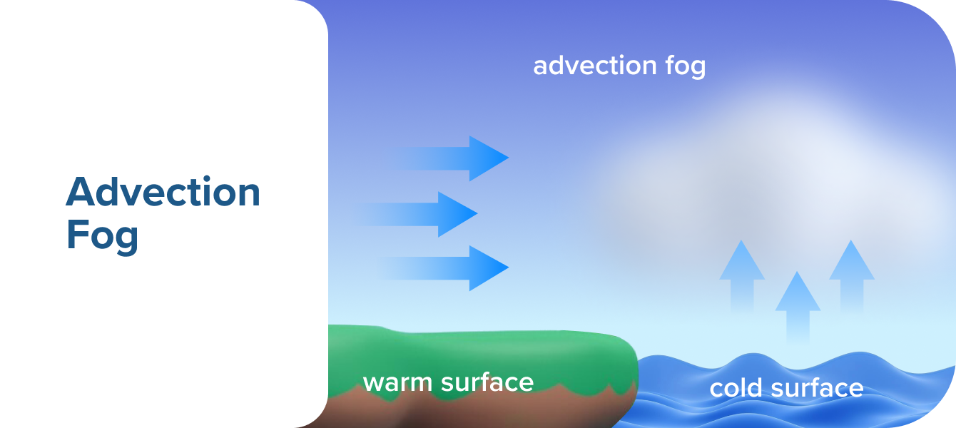
Advection fog is the great traveller of the fog world. It forms when warm, moist air moves over a colder surface, cooling to its dew point and forming widespread, low-lying fog. Unlike radiation fog, which develops overnight in still conditions, advection fog is driven by wind and can persist for extended periods, covering vast areas.
This type of fog is especially common in coastal regions, where warm ocean air meets cooler land or water surfaces. It often rolls in from the sea, engulfing runways, bridges, and harbours in thick mist. When paired with strong winds, it can reduce visibility dramatically.
How to Identify
The fog forms regardless of day or night, does not require calm winds, and can form even under cloudy skies. Persists even with stronger winds. Entire cities or airports can be affected.
Operational Considerations
Advection fog presents a serious hazard for aviation, as it can reduce visibility near airports for extended periods. It may move in rapidly, making it difficult to predict exact onset times.
How to Avoid Advection Fog
Monitor wind and temperature conditions and look for warm, humid air moving over cooler ground or water. Remember to plan for potential diversions. If advection fog is forecast, ensure alternate airports are available.
Don't let common pitfalls derail your flight training. Discover 9 crucial mistakes to avoid and stay on track to earning your wings.
Precipitation Fog
The Hidden Threat in Rainfall
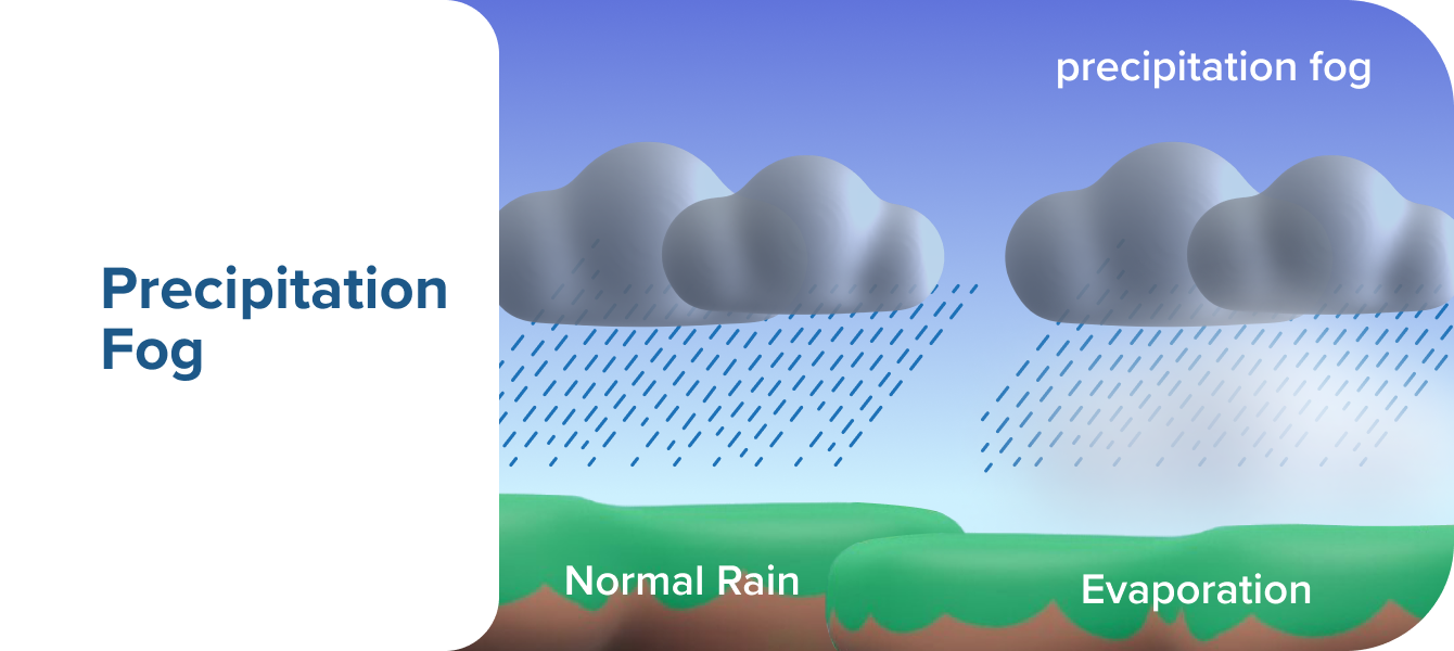
Precipitation fog is a sneaky adversary. It grows when rain falls through a layer of cold, dry air, causing evaporation, cooling, and eventual saturation. The result? A foggy mist that reduces visibility and complicates flight operations, often lingering around frontal boundaries.
Precipitation fog is commonly linked to warm fronts but can also appear with slow-moving cold fronts. Unlike other fog types that form primarily due to surface cooling, precipitation fog is driven by rain itself, making it more unpredictable.
How to Identify
Precipitation fog is associated with steady or light rain, may be found ahead of warm fronts. Can combine with low clouds to create widespread poor visibility. Forms quickly and can persist for long periods.
Operational Considerations
Avoid precipitation whenever possible. Reduced visibility combined with rain can make VFR flights unsafe. If conditions worsen, be ready to turn back and consider rerouting to clearer airspace.
Understand the key differences between Visual Flight Rules and Instrument Flight Rules. Read our blog Beyond the Clouds: VFR vs. IFR , to learn more.

Ice Fog
A Frozen Curtain in the Skies
The final letter, I in the the SURAPI acronym, stands for the one of the rarest but most dangerous types of fog. Ice fog occurs in extremely cold environments where water vapour sublimates directly into ice crystals, creating a dense, freezing mist. This type of fog is most common in locations where temperatures drop below -10°C (14°F). Unlike freezing fog (which consists of supercooled droplets that freeze on contact), ice fog is entirely made of tiny ice particles.
Ice fog is more than just a visibility issue. It presents a serious icing hazard, especially for engine intakes, wings, and propellers.
How to Identify
Ice fog appears in calm, clear, and frigid conditions and is common in Arctic and subarctic regions, including Alaska, Canada, and Siberia. It can persist for days in cold valleys where air stagnates and can be just as thick as regular fog.
Operational Considerations
Ice fog can coat aircraft surfaces, increasing weight and reducing lift. That is why check for ice accumulation, use de-icing equipment before take-off. Sheltering aircraft helps prevent excessive frost buildup. Fly at higher altitudes if necessary, as above ice fog layers, visibility improves. Proper pre-flight preparation and cold-weather operational procedures are essential when flying in regions prone to ice fog.
Beyond the Routine: Understanding Aviation Checklists covers the importance of checklists and how to use them effectively. Discover best practices for checklist management, learn how to avoid common errors, and understand why these procedures are vital for every flight.

Airhead's Takeaway
We know fog can be tricky. So, instead of a typical summary, we've created a handy chart showing you the six main fog types. Think of it as your quick-reference guide. Use it to review and reinforce your learning, and keep it close as you continue to expand your aviation weather knowledge.
Type | Where It Forms | When It Forms | Impact on Aviation | Additional Notes |
Steam Fog | Over lakes, rivers, oceans (especially in cold months) | Winter, when warm water meets cold air | Reduces visibility quickly, particularly near water crossings or low-altitude approaches | Appears as rising wispy columns |
Upslope Fog | Mountain ranges, sloped terrains | Anytime, depending on wind and terrain conditions | Increases Controlled Flight Into Terrain risk on mountainous approaches | Monitor winds and terrain for early warning |
Radiation Fog | Low-lying areas, valleys, calm regions with minimal wind | Clear, calm nights in fall and winter | Can be shallow but may reduce visibility to near zero, affecting taxi, take-off, and landing | Clears with morning sun as air warms |
Advection Fog | Coastal areas where warm air moves over cooler waters | Seasonal transitions, onshore breezes | Persistent and widespread, causing major visibility hazards near coastal airports | Monitor temperature differences and wind patterns |
Precipitation Fog | Large areas associated with frontal activity (warm fronts) | During steady or light rain | Reduces visibility significantly, often combined with low clouds and turbulence | Forms when rain evaporates into cooler air, increasing humidity |
Ice Fog | Polar regions, high-altitude temperate zones | Icy, clear conditions with high humidity | Reduces visibility and can cause engine intake and airframe icing | Consists of ice crystals, unlike freezing fog, which has supercooled droplets |


